


CIRDAP Centre on Geoinformatics Application in Rural Development (CCGARD)
CIRDAP Centre on Geo-informatics Applications in Rural Development (CCGARD) is a state-of-the-art Geospatial Application Centre situated in the CIRDAP headquarters.
The Centre is working to support the government of CIRDAP Member countries to use GIS as a tool for informed decision making, better planning and management of resources to achieve socio-economic growth. Besides engaging in research, designing, modelling and application development of Geospatial Technology Applications for the rural development sector.
Objectives:
CGARD aims to assimilate all the strengths of geospatial technology namely the GIS, Remote Sensing, Global Positioning System, ICT, and allied sectors, for potential application development for the rural development in emerging areas for scientific, optimum, productive, sustainable, environmental compliant, knowledge-based decision support, timely and need-based decision support, for faster development of rural areas and people.
Thrust area:
- Geospatial Technology Applications in planning, monitoring, modelling, and decision support systems of Watershed, Agriculture Development, Environmental Impact Assessment, Conservation practices, Natural Resources Planning, Infrastructure Development and Village Planning
- Conducting of national and international training programmes on regular basis
- To exchange ideas and experiences in formulating and implementing the GIS technologies, assess the feasibility of meeting the regional needs based on existing manpower, software, hardware and data availability and assess the training needs and resources requirements at the country level in Rural development
- Academic and research guidance to M.Sc., M.Tech. final year students and Ph.D scholars in Geo-informatics
- Online academic Geo-informatics Technology Application Programmes for field functionaries, government officials, research scholars, NGO members etc.
The CGARD renders its support to functionaries at different levels like field level officials, Central and State Government Ministries and Departments, District Level Functionaries, National and International Agencies in Geoinformatics Technology Applications in Rural Development sector and allied areas.
The centre was established with generous support from Ministry of Rural Development, Government of India and National Institute of Rural Development and Panchayati Raj (NIRD&PR).
GEOINFORMATICS APPLICATION IN RURAL DEVELOPMENT:
Agriculture Resources:
- Crop acreage, Production estimation and Remote Sensing based crop yield model.
- Crop condition assessment, Agriculture drought assessment
Land Resources:
- Land records modernization, updation, digital data base, irrigability, suitability, capability, productivity.
Landuse/Land cover:
- Landuse/Land cover mapping and district level wasteland mapping.
- Urban sprawl studies and growth center analysis.
Forests:
- Forest cover mapping, Monitoring and forest fire and risk mapping.
- Bio-diversity conservation and Environmental impact studies.
- Grassland productivity and potential.
Water Resources:
- Surface water mapping, flood damage assessment, risk zone mapping and identification of flood embankment sites.
- Runoff forecasting, reservoir, sedimentation and drainage congestion studies.
Geoscience:
- Landslide hazard zonation mapping
- Mineral exploration
Internation Geosphere &Biosphere:
- Atmospheric minor constituents and aerosols
- Land –Air ocean interaction
- Past climate data modelling
Land and Water development activities:
- Land improvement, Implementation of Land reforms, Land consolidation and Soil conservation, Minor irrigation, Water management and Watershed.
Productive activities:
- Agriculture, Animal husbandry, Dairying and poultry, fisheries, social forestry and form forestry.
- Minor forest products, small scale industries, cottage industries, fuel and fodder.
Social welfare activities:
- Poverty alleviation programmes, cultural activities, family welfare, women and child development, social welfare (Including the handicapped and mentally challenged) and the schedule castes and schedule triples.
Governance Activities:
- Markets and fairs, public distributions stop.
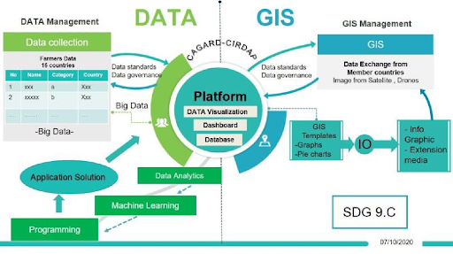
The Governing Council (GC-19) resolution in 2013 approved the establishment of the CIRDAP Information Centre, known as the Centre on Geoinformatics Applications in Rural Development (CGARD). This centre was established in 2017 with generous support from the Ministry of Rural Development, Government of India, and National Institute of Rural Development and Panchayati Raj (NIRD&PR), India, to support the government of CIRDAP Member countries to use GIS as a tool for informed decision making, better planning, and management of resources to achieve socio-economic growth, besides engaging in research, designing, modeling and application development of Geospatial Technology Applications for the rural development sector.
Mr. Supawat Komolmarl, an Expert of CIRDAP, prepared a strategic plan of CCGARD and the presented at the Technical Committee (TC-36) meeting, 2021 and the strategic plan was endorsed at the Executive Committee (EC-33) and Governing Council (GC-23) meeting in 2022, respectively. This CGARD Strategic Plan is intended to serve as guidance for moving from initial stage to advance stage. This plan clearly outlines the mission, objectives and goals of this initiative as well as strategies on how it will be achieved. This plan will allow the CIRDAP to better leverage its GIS/MIS investments and ensure that priorities for GIS/MIS technology and related business processes are aligned with CIRDAP’s objectives. The scope of this document is targeted primarily at the 2020-2024 calendar years. At the end of this period a comprehensive review will be done to assess progress-to-date and for future direction.
Check out the Strategic plan of CCGARD: Click Here
CIRDAP CGARD Scientists

Dr. J. RAJESH